The North Atlantic Oscillation Explained
The natural phenomenon dictates the severity of winter in the northern hemisphere

Published On 30 Jan 2012
 |
| The beginning of winter was very mild in Europe and North America, with very little snow even on the Alps [REUTERS] |
The North Atlantic Oscillation (NAO) is a natural phenomenon, much like La Nina or El Nino. However, whereas La Nina sets up in the waters of the Pacific, the NAO is centred in the atmosphere above the Atlantic.
The definition of the NAO is the difference in pressure between Greenland and the Azores. When the pressure is low over Greenland and high over the Azores, the NAO is said to be in a positive phase. This set up encourages the air to flow northeast across the Atlantic into Europe. The weather for both North America and Europe is mild.
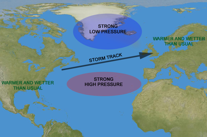 |
| The positive phase of the North Atlantic Oscillation brings mild weather in Europe and North America [Al Jazeera] |
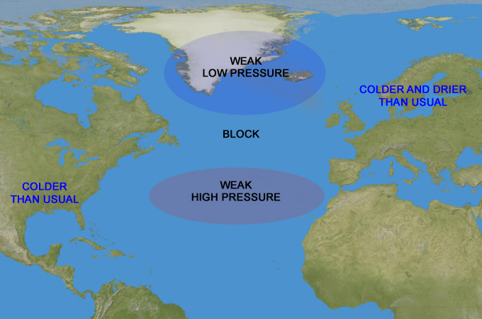
In a negative phase, the pressure over Greenland and Azores are similar. This sets up a blocking pattern across the Atlantic. The mild weather from the southwest is prevented from getting to Europe and it also makes things cooler for North America too. The weather is prevented from flowing out of eastern parts of the States, and the cold weather lingers.
 |
| The negative phase of the North Atlantic Oscillation causes a cold spell over Europe and North America [Al Jazeera] |
As you may have guessed, in the winter of in 2009-10 and 2010-11 the NAO was strongly negative, bringing cold weather with plenty of snow.
Keep reading
list of 4 itemsPhotos: Heavy rains, lightning in Pakistan kill at least 50 people
Inside the pressures facing Quebec’s billion-dollar maple syrup industry
Coral reefs around the world experiencing mass bleaching, scientists say
However, the NAO doesn’t have to stay in one phase for an entire winter and predicting the NAO is the cause of many headaches for meteorologists.
Despite having such an acute effect on our weather, the NAO can only be forecast for two weeks in advance and even then the accuracy is not perfect. This is just one reason why a long range forecast should always be taken with a pinch of salt.
Source: Al Jazeera