The Gaza Strip explained in maps
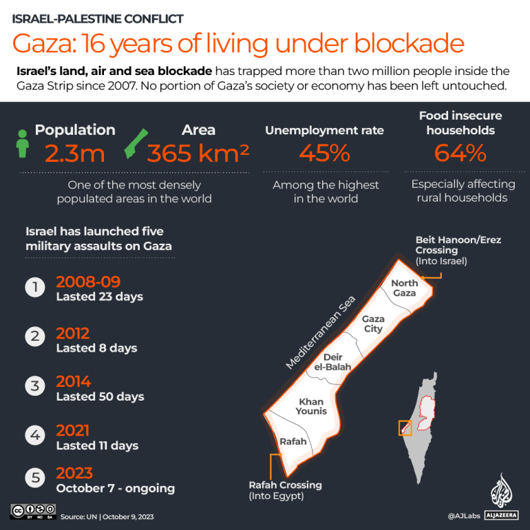
The Gaza Strip, home to 2.3 million people, has been under an Israeli-imposed land, sea and air blockade for the past 16 years.
Published On 7 Aug 2022
|
Updated:
9 Oct 2023
12:10 PM (GMT)
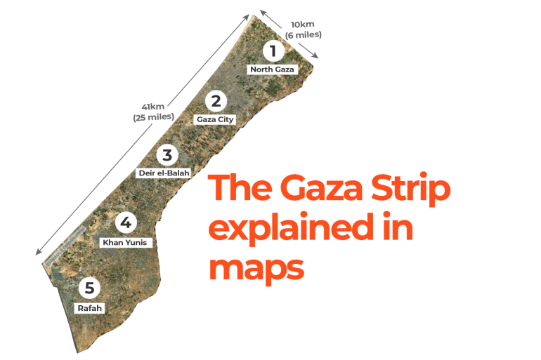
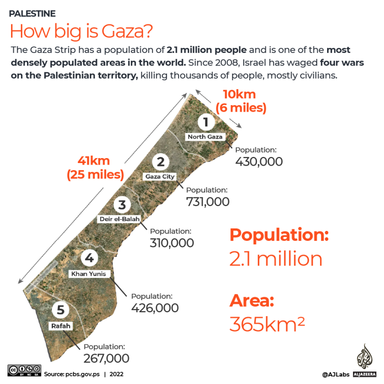
Gaza has a population of about 2.3 million people living in five governorates: North Gaza, Gaza City, Deir el-Balah, Khan Younis, and Rafah.
Bordered by Israel and Egypt on the Mediterranean coast, the strip is about 365 square kilometres (141sq miles). At only 41km (25 miles) long, it can take less than an hour to drive from Rafah in the south to Beit Hanoon in the north.
Keep reading
list of 4 itemsWatching the watchdogs: The media downplays a big legal story at its peril
Satellite images show Israeli forces gathered for Gaza escalation
Incessant attacks continue after 200 days of Israel’s war on Gaza
In the following series of maps, Al Jazeera takes you on a journey across Gaza’s five governorates, highlighting key locations, including hospitals, schools, universities, UN compounds, refugee camps, crossings and other vital infrastructure.
Sixteen years of Israeli blockade
Since 2008, Israel has waged four wars on the Palestinian territory, killing thousands of people, mostly civilians. During Israel’s last offensive on Gaza, Israeli attacks killed at least 256 people, including 66 children, and wounded 2,000, according to the United Nations.
The 11-day assault damaged at least 51 education facilities, including 46 schools, two kindergartens, a United Nations Relief and Works Agency for Palestine Refugees in the Near East (UNRWA) training centre, and parts of the Islamic University of Gaza, according to the UN.
Israeli raids also damaged at least six hospitals and 11 primary healthcare centres, including Gaza’s only COVID-19 testing laboratory.
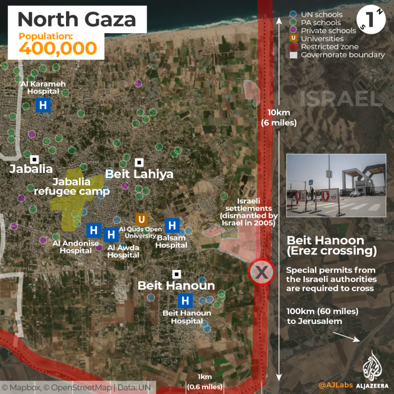
North Gaza
The district of North Gaza shares a 10km (6 miles) long border with Israel. The Gaza Strip is surrounded by a heavily fortified perimeter consisting of a concrete wall and double-wired fencing. Anyone who steps within 1km (0.6 miles) of this barrier is in danger of being shot by the Israeli army, which patrols Gaza’s northern and eastern borders.
The Beit Hanoon crossing, known as Erez to Israelis and managed by the Israeli army, is Gaza’s only northern crossing into Israel. From there, Palestinians with special permits – usually for urgent medical treatment – are allowed to leave Gaza on their way to Jerusalem or the West Bank. Gaza is only about 100km (62 miles) from Jerusalem, but because of tight security measures, it becomes several hours of journey. Since 2007, Israel has imposed a sea and air blockade of Gaza.
North Gaza is home to the largest refugee camp in the Strip. The Jabalia refugee camp covers an area of 1.4sq km (0.5sq miles), and with a population of 114,000, it is one of the most densely populated places on Earth.
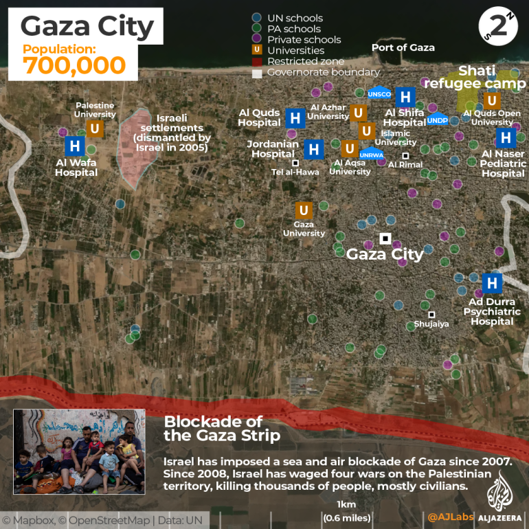
Gaza City
Gaza City is the largest and most populous city within the Gaza Strip, with more than 700,000 residents. Rimal, Shujaiya and Tel al-Hawa are among its most well-known neighbourhoods.
At the heart of the Rimal neighbourhood is Al Shifa Hospital – the largest medical facility in the Gaza Strip.
Surrounding the hospital are several UN compounds, including UNRWA, the Office of the United Nations Special Coordinator for the Middle East Peace Process (UNSCO) and the UN Development Programme (UNDP). Gaza’s top universities – including the Islamic University of Gaza, Al-Azhar University – Gaza and the Al-Aqsa University, which are just a few hundred metres apart – are also located in the Rimal neighbourhood.
The Shati refugee camp, also known as Beach Camp, is located along Gaza’s Mediterranean coastline and is the third-largest out of the Gaza Strip’s eight camps.
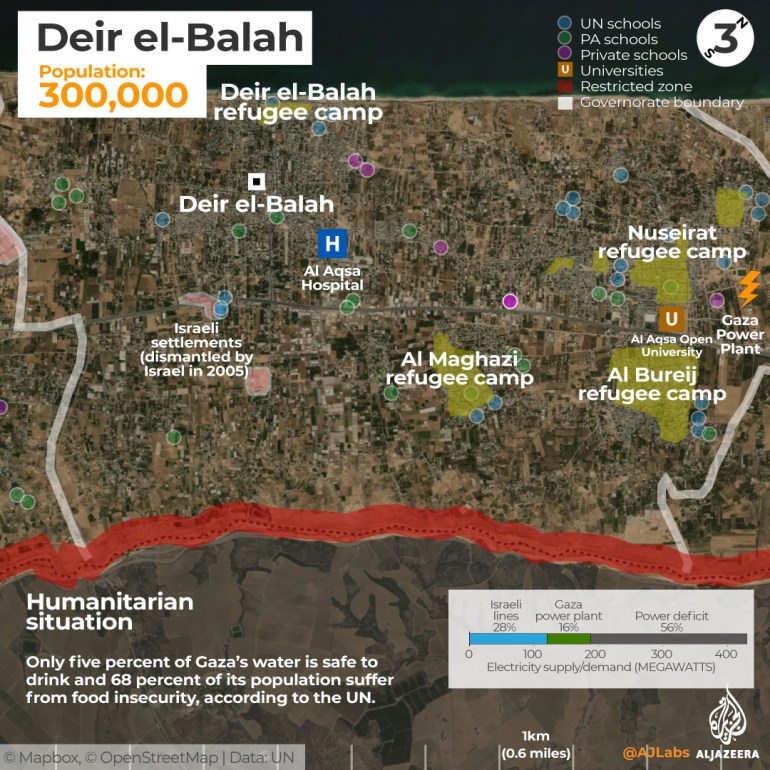
Deir el-Balah
Named after the “Monastery of the Date Palm”, Deir el-Balah is one of Gaza’s largest agricultural producers. It is also home to four refugee camps: Nuseirat, Al Bureij, Al Maghazi and Deir el-Balah.
Gaza’s only operating power plant is located along the district’s boundary with Gaza City. For the past 10 years, the Gaza Strip has suffered from chronic electricity shortages, which have severely affected its ability to provide essential services including health, water and sanitation services, manufacturing and agriculture.
Only 5 percent of Gaza’s water is safe to drink and 68 percent of its population suffers from food insecurity, according to the UN.
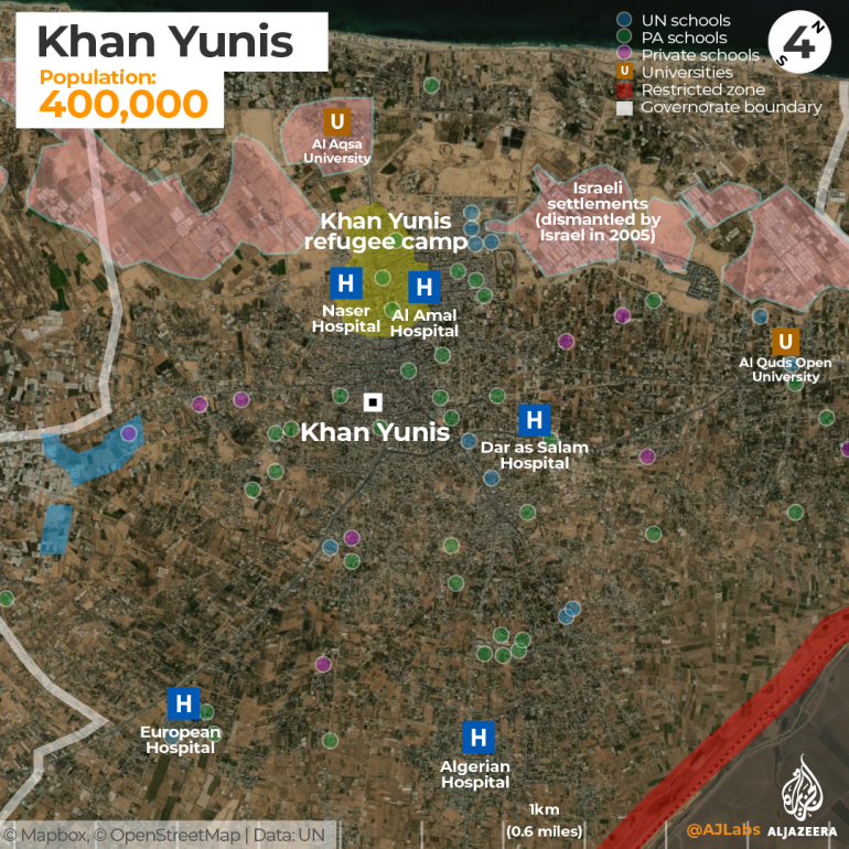
Khan Younis
The district of Khan Younis is home to some 400,000 people. At its centre is the Khan Younis refugee camp, home to about 87,000 people.
In 2005, nearly 8,000 Jewish settlers and Israeli soldiers living in 21 settlements around Gaza were relocated mostly to the occupied West Bank following a decision by then-Israeli Prime Minister Ariel Sharon to unilaterally disengage from the Gaza Strip. Most of these settlements were in Khan Younis.
Israel claimed its occupation of Gaza since 1967 has ended as it has pulled its troops and settlers from the territory but international law views Gaza as an occupied territory because Israel has full control over Gaza’s borders, airspace and territorial waters.
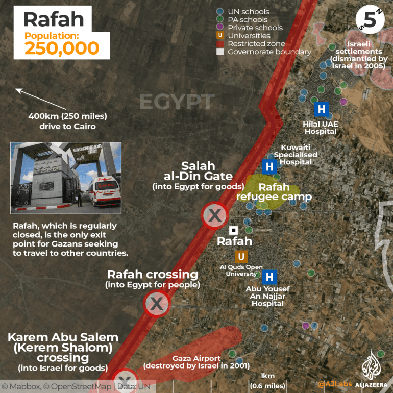
Rafah
Rafah is the southernmost district of Gaza with a population of more than 250,000. The district is best known for the crossing with Egypt that bears its name.
Both Israel and Egypt have kept their borders largely shut, and are responsible for further deteriorating the already-weakened economic and humanitarian situation.
In 2020, the Rafah crossing and the Erez crossing into Israel were open for only 125 days, according to the UN. Palestinians who wish to leave must apply for a limited number of passes to leave the Gaza Strip. This process may take weeks or months, depending on the status of the border.
Those who are able to get through the Rafah crossing must then make a six-to-eight-hour journey through the Sinai Desert passing several Egyptian checkpoints on their way to Cairo, about 400km (250 miles) away. Rafah’s second crossing into Egypt is the Salah al-Din gate, which is used for transporting goods.
The third crossing from Rafah is the Israeli-controlled Karem Abu Salem crossing, known as Kerem Shalom to Israelis.
Gaza has no functional airports after Israel bombed and demolished the Yasser Arafat International Airport in 2001, only three years after it opened.
Gaza again is the scene of widespread destruction and human suffering and remains the place often described as “the world’s largest open-air prison”.
Source: Al Jazeera