Mapping methane: Satellites seek out gas-spewing waste sites
A first-of-its-kind waste map under development shows methane emissions at landfills around the world in new fight against climate change.
Published On 26 Oct 2023
Surprises came quickly when the Global Methane Hub, a non-profit that seeks to reduce emissions of the potent greenhouse gas, began looking at satellite images taken of landfills from around the world.
Scientists from SRON, the Netherlands Space Research Institute, fixed infrared cameras on their satellites. They could detect methane emissions, high levels of which showed up as red clouds hanging over landfills in the photographs.
Keep reading
list of 4 itemsNord Stream leaks likely single largest methane release ever: UN
I thought fossil fuel firms could change. I was wrong
Energy agency praises green tech advances, pushes fossil fuel phase-out
Landfills in Mumbai, New Delhi, Buenos Aires and several other cities showed large, red patches although some had measures in place to separate food and other organic waste that emanate methane as they decompose.
“Organic waste has been made visible through satellite,” said Marcelo Mena, chief executive of the Global Methane Hub.
The hub recently announced it received a $5m grant from Google.org to fund this first-of-its-kind waste map, which will show methane emissions at landfills around the world. Google will also build artificial intelligence models to better map landfills and their methane emissions.
The map will be launched as a website at COP28, the international climate talks to be held in Dubai in November and December.
“We will create new artificial intelligence and data tools to see waste sites,” said Brigitte Hoyer Gosselink, director of AI and sustainability at Google.org. “It is a very diffuse problem, so you don’t think there are emissions in places we can now see them at.”
‘Make strategies’
Methane is a leading cause of climate change as it is a powerful greenhouse gas responsible for about 30 percent of the rise in global temperatures since the Industrial Revolution. It is the second largest contributor to global warming after carbon dioxide.
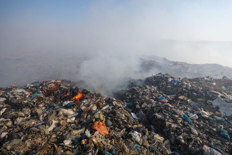
Oil and gas production, agriculture and landfills are major sources of the gas. Methane emissions from landfills aren’t visible to the human eye, but they can lead to fires and smoke in the cities where they are located.
More than 146 countries have signed the Global Methane Pledge, committing to reduce emissions of the gas by 30 percent by 2030 from 2020 levels. The agreement underscores the need to document and quantify such emissions.
The waste map will have global coverage of landfill sights, far more than the few it had at its pilot stage.
Jack McQuibban, head of implementation at Zero Waste Europe, a non-profit that lobbies for reducing waste, said he is waiting for European landfills to be included so he can start following emissions from them. “If you have data, you can make strategies,” he said.
For instance, studying landfills with high emissions could help researchers see patterns. The HORECA, or hotel, restaurant and conventions sector, could be a large contributor, McQuibban said, since food waste leads to such emissions. And working with this sector on preventing waste from reaching landfill could help reduce the gas.
The Global Methane Hub is working with authorities in New Delhi, Mumbai, Santiago in Chile and several other cities on solutions to cut down landfill emissions.
This could include easy fixes, such as finding and addressing potential breaks in pipes meant to capture and release methane. It could also mean covering landfills at the end of the day. Or it could involve organising separate collections for organic waste and using it to make compost as cities such as Durban and Pune have done.
‘Single most important tool’
Mena said satellite imagery will help document successes at cutting down methane emissions and help replicate successful practices.
“It is the single most important tool that a mayor has,” he said, referring to data that is able to show that diverting organic waste from landfills could lead to reduced emissions and better air quality.
“When I was an environmental authority, I was aware that we needed to do something,” said Mena, who was the environment minister of Chile. “But we didn’t have any tools.”
SRON first published its research and satellite photographs of landfills in the scientific journal Scientific Advances in 2020. It showed city-level methane emissions to be 1.4 to 2.6 times higher than estimated. It also showed landfills with high emission levels in New Delhi, Lahore, Mumbai and Buenos Aires.
One in Kanjurmarg, Mumbai, emitted 85,000 tonnes of methane a year, and the one in Buenos Aires emitted 250,000 tonnes a year, the SRON study found.
Kanjurmarg was developed after Mumbai’s more than a century-old landfill at Deonar filled far beyond capacity. Most of Mumbai’s waste began going to Kanjurmarg after a series of fires erupted at Deonar in 2016, which filled Mumbai with toxic smoke.
But environmental groups have filed a court case asking to close the Kanjurmarg landfill, citing a violation of a range of environmental norms and questioning the waste-processing systems followed there.
‘Extent of the problem’
Vamsi Shankar Kapailai, senior researcher with the Citizen Consumer and Civic Action Group, said Chennai’s dumps are also “methane ticking bombs”. Last year, there were large fires at the city’s Perangudi landfill, but in good news, Vamsi said, “when we take data, they [the municipal authorities] are receptive.”
Having a better estimation of methane emissions from landfills will “really show the extent of the problem”, said Mariel Viella, global climate change programme director at the Global Alliance for Incinerator Alternatives.
“The environmental impact and toxic fumes from landfills have been felt by communities around them, such as waste pickers, for many years,” Viella said.
As the waste map expands, Mena said, he hopes to add more landfills to it.
Feeding this data into Google’s artificial intelligence tools could also help detect informal landfill sites not included earlier, Gosselink said.
In Chennai for instance, with landfills filled to the brim, citizens began dumping waste in the campuses of government offices. Currently, the satellites photograph only landfill locations provided by cities and non-profits although such informal dumpsites could emit methane too.
The AI tools could also measure methane emissions with greater efficiency. Having the map on a website will also allow internet users to report any undetected sites.
“Our hope is to have a global picture [of methane emissions from landfills],” Gosselink said, adding that it will be a first step towards reducing dangerous methane emissions.
Source: Al Jazeera