Hurricane Patricia breaks several records
The most destructive force brought by Hurricane Patricia is likely to be the storm surge, but floods will follow inland.
Published On 24 Oct 2015
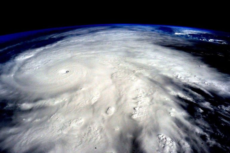
Hurricane Patricia came ashore on Friday night, crossing the Mexican coast between Manzanillo and Puerto Vallarta. At that time, Patricia was still a Category 5 hurricane, at the top of the Saffir-Simpson Scale.
An automatic wind sensor just south of Chamela, right in the path of the most intense winds, reported a steady blow of 300km/h and gusts of 340km/h.The weather station in Manzanillo stopped reporting at 18:00GMT, just as the wind and rain were picking up.
Keep reading
list of 4 items‘It’s going to be worse’: Brazil braces for more pain amid record flooding
The everyday items you never knew contained plastic
‘Don’t be afraid for the marshes’: The battle to save Iraq’s waterways
| A BRIEF HISTORY OF NAMED TROPICAL CYCLONES KNOWN TO HAVE HIT MEXICO |
|
JANET
The first Category 5 hurricane to be recorded made landfall on September 27, 1955, in the eastern state of Quintana Roo, crushing wooden homes in the capital city of Chetumal and killing hundreds of people.
MEXICO
Until Patricia, it was considered the most powerful to have formed in the Pacific, a Category 5 hurricane with 260km/h winds. It smashed into the coast on October 29, 1959, near the port of Manzanillo, leaving more than 1,000 people dead.
BEULAH
It crashed into Quintana Roo on September 16, 1967, around the resort of Cozumel, then returned to the Atlantic where it regained force and reached Category 5 power before slamming northeastern Mexico and the US state of Texas. Some 40 people died in Mexico.
LIZA
This Pacific hurricane reached Category 4 on September 30, 1976, before striking the southern part of Baja California peninsula. More than 1,000 died and the homes of tens of thousands of people were damaged.
GILBERTO
The Category 5 hurricane made landfall on September 14, 1988, on the Caribbean island of Cozumel before crashing into the Cancun resort. It returned to the Atlantic and then slammed into northeastern Mexico. The storm caused major flooding in the industrial hub of Monterrey. Some 200 people died, mostly in Monterrey.
PAULINE
Hurricane Paulina killed hundreds of people after making landfall on October 8, 1997, in the southern state of Oaxaca. Hours later, it moved into neighbouring Guerrero state, producing record rainfall and a landslide. Hundreds died.
WILMA
This erratic hurricane made landfall in Cozumel as a Category 4 storm on October 21, 2005, and pummelled Cancun and the Riviera Maya for 48 hours. Eight people died.
MANUEL AND INGRID
Mexico was hit nearly simultaneously by Tropical Storm Manuel and Hurricane Ingrid on both coasts in September 2013, a rare double landfall that left 157 people dead, including dozens who were buried in a mudslide in Guerrero.
|
Despite the strength of the winds, the most destructive force brought by Hurricane Patricia is likely to be the storm surge.
The eye of a hurricane is a centre of low pressure and the ocean surface is drawn up into it, in an attempt to fill it.
The lower the pressure, the higher the dome of ocean surface that follows it.
Patricia’s central pressure was 880mb which is extremely low and is likely to have lifted the Pacific below it by five metres.
Such a storm surge, an unstoppable five-metre tall hill of ocean water, is irresistible and only daylight in Mexico will reveal the damage.
Related: Mexico in a state of emergency as storm hits coast
The path taken by Patricia towards Mexico is unusual; hurricanes will typically turn away from Mexico and out into the Pacific.
In fact, there was a brief wobble observed in the track a few hours before landfall, when it appeared that such a left turn was possible.
Much has been said about Patricia’s record-breaking status, and this is where the reliability and accuracy of records come into play.
Measurements these days are helped by satellite instrumentation and better radar accuracy.
Prior to 1960, visual estimation of winds was used above about 180km/h as sea spray blinded the radar.
Bearing this in mind, these are the records set by Hurricane Patricia:
• The highest reliably measured surface winds on record for a tropical cyclone, anywhere on the Earth
• Central pressure of 879mb – the lowest pressure ever measured in a hurricane in the Western Hemisphere
• Patricia’s central pressure dropped an astonishing 100mb in 24 hours, making it the fastest-intensifying hurricane ever observed in the Western Hemisphere.
If the storm surge is indeed confirmed at five metres, it would be the largest storm surge in the modern history of western Mexico.
On the other side of the dateline, in the western Pacific, hurricanes are called typhoons.
They are the same beast, only the name changes: In fact, when a hurricane crosses longitude 180 degrees, it is renamed as a typhoon.
In an El Nino year, typhoons often reach the Saffir-Simpson category 5. These cyclones have so far provided the most extreme figures: Super Typhoon Nancy (1961), Super Typhoon Violet (1961), and Super Typhoon Ida (1958) all have been listed with winds over 320km/h, but these are now thought to be too high by at least 16km/h.
The record lowest pressure inside a tropical cyclone is held by Super Typhoon Tip of 1979: 870mb.
Patricia is estimated to have intensified by 160km/h in 24 hours, from a tropical storm to a Category 5 hurricane. Hurricane Linda, (in the Eastern Pacific) of 1997 is the only storm on record to have intensified at this rate. 1997 was also an intense El Nino year.
Now over land, Patricia has encountered very rugged terrain, triggering torrential rains with the risk of severe flooding and landslides.
The mountainous trek will shred Patricia’s low-level circulation quickly, but the hurricane’s upper-level circulation will carry on northeastward, arriving near southern Texas by Sunday.
The rainfall potential in Texas for Sunday and Monday is large – 100 to 200mm is likely to be widespread, and 300mm is possible.
Source: Al Jazeera, News Agencies