Australia braces for Cyclone Debbie
Cyclone Debbie is forecast to be the strongest storm of the season yet.
Published On 25 Mar 2017
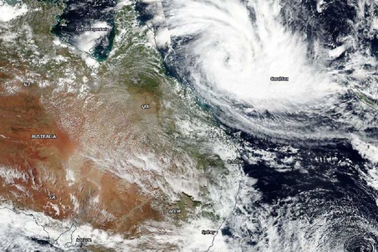
It has been a relatively quiet cyclone season for Australia so far, but the next cyclone, which is now intensifying in the Coral Sea, could be the strongest one yet.
Cyclone Debbie lingered as a tropical wave for days in open water, but on Saturday was upgraded to the equivalent of a tropical storm.
Keep reading
list of 4 itemsCanada wildfires spur evacuation orders, warnings: What you need to know
Evacuation orders issued as wildfire grows near Canada’s Alberta oil patch
‘Unbearable’: Will 45C heatwaves affect who India chooses in election?
As of 4pm local time [05:00 GMT], the system was 640km east of Cairns and 560km east northeast of Townsville, with sustained winds of 65km per hour.
Currently, the cyclone is expected to make landfall along the northern Queensland coast between Townsville and Proserpine on Tuesday morning.
Forecast models were predicting that Debbie could intensify to a category 4 cyclone with wind gusts of up to 260km/h near its centre before making landfall.
But with water temperatures in the Coral Sea over 29 degrees Celsius, the storm has the time and the fuel to possibly intensify further.
On Saturday afternoon, a cyclone watch was in place from Cape Tribulation to St Lawrence, including Cairns, Townsville and Mackay.
Potentially over 300 millimetres of rain could be expected with this storm, particularly along coastal sections of Queensland and inland. Destructive winds along with coastal and flash flooding are the major threat to the region.
On average, Australia sees about 11 cyclones a year. So far for the 2016-2017 season, the country has only seen four cyclones of tropical storm strength make landfall on the continent.
In early March, Cyclone Blanche became the strongest storm of the season so far with sustained winds of 95km/h. The cyclone made landfall in a relatively uninhabited section of Western Australia but was responsible for dumping 145mm of rain in Darwin in just 24 hours.
Source: Al Jazeera, News Agencies